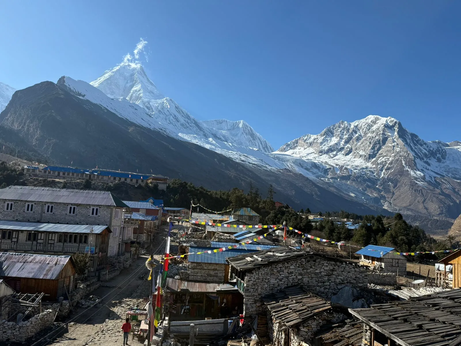
What Is the Manaslu Circuit Trek? A Full Guide
Picture a giant mountain, so tall it pokes through the clouds, with a trail that walks all the way around it. That's basically what the Manaslu Circuit Trek is. You start low down in green farmland, and over about two weeks you climb higher and higher until you're crossing a snowy pass at over 5,000 metres, then you come back down the other side into a completely different valley.
The mountain itself is called Manaslu. It's 8,163 metres tall, which makes it the eighth-highest mountain on Earth. The trek doesn't go up the mountain — nobody without serious climbing gear and experience is doing that — it just loops around the base of it, through the Gorkha district in Nepal, close to the border with Tibet. Because the area is protected and a bit remote, you can't just wander in on your own. You need a permit, and you need to go with a licensed guide. That might sound like a hassle, but honestly, it's part of what keeps this trek so peaceful. You won't be shuffling along in a queue of a hundred other trekkers like you might on Everest Base Camp.
So here's the short version: it's roughly 135 to 180 kilometres of walking, spread over 12 to 14 days, reaching a highest point of 5,106 metres at a place called Larkya La Pass. It's not technically hard — no ropes, no climbing gear — but it is a serious physical challenge because of the altitude and the sheer number of days on your feet.
What Are the Quick Facts of the Manaslu Circuit Trek?
If you only have thirty seconds, here's everything in one table.
Detail | Info |
| Distance | 135–180 km (depends on the route and side trips) |
| Duration | 12–14 days |
| Start / End | Machha Khola or Soti Khola → Dharapani or Besisahar |
| Highest point | Larkya La Pass, 5,106 m |
| Difficulty | Moderate to challenging |
| Permits needed | RAP, MCAP, ACAP |
| Guide | Mandatory |
| Where you sleep | Teahouses (small lodges) |
| Best months | September–November, March–May |
| Rough cost | $900–$1,600+ per person |
Where Is the Manaslu Circuit Trek Located?
Manaslu sits in the Gorkha district, in Nepal's Gandaki Province, tucked between the Annapurna region and Tibet. The whole trek follows a river called the Budhi Gandaki up through its valley, gradually leaving the warm lowlands behind and climbing into proper high-mountain territory. By the time you're near the pass, you're only a stone's throw from the Tibetan border — you can even see it from some of the higher villages. The area is officially called the Manaslu Conservation Area, and it's one of Nepal's less-visited corners, which is exactly why people love it.
Why Should You Choose the Manaslu Circuit Trek?
There isn't one single reason people pick Manaslu over, say, Everest Base Camp. It's really a mix of things — fewer crowds, wilder scenery, and a culture that still feels untouched by mass tourism. Let's break that down a bit.
Is the Manaslu Circuit Trek Quieter Than EBC and Annapurna?
Yes, by a long way. In 2024, roughly 250,000 people trekked the Annapurna Base Camp route. Everest Base Camp had about 50,000. Manaslu? Around 12,000. That's not a typo — it really is that much quieter. Part of the reason is the permit system itself: because Manaslu is a restricted area, only so many trekkers pass through the checkpoints each season, and you can't just show up without paperwork. It naturally filters the crowds out. So if the idea of sharing a trail (and a teahouse dining room) with dozens of strangers every night doesn't appeal to you, this is your trek.
What Landscapes and Ecosystems Will You See on the Trek?
This is honestly one of the wildest parts of the whole experience. You start down around 600–900 metres, in warm, jungly, almost tropical-feeling forest with rice paddies and waterfalls. Within a week you're walking through pine and rhododendron forest, and a few days after that you're above the treeline entirely, surrounded by glaciers and bare rock. Very few treks in the world let you walk through that many completely different worlds in a single trip.
What Tibetan-Influenced Culture Will You Experience?
The higher you go, the more the culture shifts. Down low, you'll pass through villages where people are mostly Gurung. Higher up, especially around places like Samagaun and Samdo, you're firmly in Tibetan Buddhist territory — monasteries, spinning prayer wheels, walls covered in carved mantras, strings of colourful prayer flags snapping in the wind. It doesn't feel staged for tourists. It feels like people are just living their lives, and you happen to be walking through.
How Long Is the Manaslu Circuit Trek in Distance and Days?
Here's where sources genuinely disagree a little, so let's clear it up. The "core" trek — the direct route without any detours — is roughly 135 kilometres. But almost nobody does just the core route, because the best side trips (like the hike up toward Manaslu Base Camp, or the walk to Pungyen Gompa monastery) add extra distance. Once you include those, the total climbs to somewhere between 160 and 180 kilometres. If you tack on the Tsum Valley extension too, it can stretch past 240 kilometres.
Days-wise, plan for 12 to 14 days of actual trekking. You'll sometimes see people claim they did it in 10 or 11 days — and sure, it's physically possible — but almost every guide and agency will tell you not to. Cutting days usually means cutting the acclimatization time your body needs, and that's a genuinely risky trade-off at this altitude. You gain roughly 11,000 metres of elevation over the whole trek and lose about 9,850 metres coming back down — which, when you add it up, is a lot more total climbing than the summit height alone suggests.
How Difficult Is the Manaslu Circuit Trek?
Most people land somewhere between "moderate" and "challenging" when they describe it, and that's probably fair. You don't need ropes or crampons for technical climbing. What you do need is stamina, patience, and respect for the altitude. Let's go through what actually makes it tough.
How Does Altitude and Acclimatization Affect the Trek?
This is the single biggest factor. As you climb higher, there's less oxygen in the air, and your body needs time to adjust. The trek is designed with a built-in rest day at Samagaun (3,530 m) specifically for this reason — you might do a short hike that day, but you sleep at the same altitude both nights, which helps your body catch up. Some people add a second rest day at Samdo too. The rule guides love to repeat is "climb high, sleep low" — meaning it's fine to hike up to a higher point during the day, as long as you come back down to sleep lower.
If you skip acclimatization or push too fast, you risk Acute Mountain Sickness — headaches, nausea, loss of appetite, dizziness. Ignored, it can turn into something much more serious (HAPE or HACE, which affect the lungs and brain). Nobody wants that. So the golden rule is simple: don't rush, and tell your guide the moment you feel off.
What Is the Terrain and Daily Walking Time Like?
Most days you're walking somewhere between four and nine hours, depending on the stage. The trail itself isn't technically hard — it's mostly dirt paths, stone steps, and a fair number of swinging suspension bridges over rivers. A few sections can get slippery or landslide-prone, especially if it's rained recently, so you do need to watch your footing. But nobody needs mountaineering skills to walk it.
How Does the Weight You Carry Affect Difficulty?
Here's something people underestimate: how much you carry matters almost as much as your fitness level. If you're hauling your own full pack every day, the trek gets noticeably harder. Most trekkers hire a porter, who can typically carry 20 to 25 kilograms (usually shared between two trekkers), while you walk with just a light daypack. It genuinely changes how much energy you have left at the end of each day.
Is Manaslu Harder Than Everest Base Camp or Annapurna Circuit?
Honestly, people don't fully agree on this one, so it's worth hearing both sides. Some experienced trekkers say Manaslu feels harder than the Annapurna Circuit and roughly as tough as Everest Base Camp — mainly because it's longer and more remote, with fewer facilities to fall back on if something goes wrong. On the other hand, Everest Base Camp's side trip to Kala Patthar actually reaches a higher point (5,545 m) than Larkya La Pass. So it depends what you're measuring — total distance and isolation, or peak altitude. Neither trek is "easy," and comparing them too precisely probably isn't that useful. Just know Manaslu is a serious undertaking either way.
What Is the Manaslu Circuit Trek Itinerary (12–13 Days)?
Below is the classic route almost every guide agency follows, give or take a day here or there. Some operators split days slightly differently, and a few offer 10-11 day "short" versions or 14-day versions with extra acclimatization — but this is the shape of the trip you'll see again and again.
What Happens on Day 1: Kathmandu to Machha Khola?
You'll spend most of this day just getting to the trailhead — it's an 8 to 10 hour drive covering around 160 kilometres, through Dhading and Arughat, ending at the small riverside village of Machha Khola. It's bumpy, it's long, but it's also the last day you'll be sitting down for a while.
What Happens on Day 2: Machha Khola to Jagat?
Now the actual walking begins. It's around 16 to 22 kilometres, roughly 6 to 8 hours, passing through villages like Khorlabesi and a natural hot spring called Tatopani. You'll arrive in Jagat, a stone-paved village at about 1,340 metres, where you also enter the official Manaslu Conservation Area.
What Happens on Day 3: Jagat to Deng?
You'll pass through Philim, where your permits get checked again, then continue through increasingly quiet countryside to Deng, sitting at around 1,860 metres. You'll start catching glimpses of Shringi Himal in the distance on a clear day.
What Happens on Day 4: Deng to Namrung?
This is where things start to feel different. The trail climbs through villages like Ghap and Bihi, and you'll notice mani walls and small chortens (Buddhist shrines) starting to appear along the path — your first real sign you're entering Tibetan Buddhist territory. You'll end the day in Namrung, at about 2,630 metres.
What Happens on Day 5: Namrung to Lho or Shyala?
Depending on your itinerary, you'll stop either at Lho (around 3,135 m, home to a monastery called Ribung), or push on a little further to Shyala (about 3,500 m), which puts you in a slightly better position for acclimatizing. Either way, this is usually the day you get your first proper, unobstructed view of Mount Manaslu itself.
What Happens on Day 6: Lho or Shyala to Samagaun?
A relatively short, scenic walk brings you to Samagaun, the largest village on the whole route, sitting around 3,520 to 3,530 metres. This is where you'll spend two nights, and it's where the Nubri people — a Tibetan-origin community — really shape daily life around you.
What Happens on Day 7: The Acclimatization Day at Samagaun?
This isn't a lazy day off, even though it's called a "rest day." Most trekkers use it to hike somewhere and come back to sleep at the same altitude. Popular options include a short walk to Birendra Lake (a glacial lake about 2 kilometres away), a visit to Pungyen Gompa monastery at roughly 4,040 metres, or — for the more ambitious — the demanding hike up toward Manaslu Base Camp at around 4,800 metres, which can take 8 to 10 hours round trip and is genuinely one of the toughest single days on the whole route.
What Happens on Day 8: Samagaun to Samdo?
A shorter day, about 3 to 5 hours, brings you to Samdo at roughly 3,870 to 3,875 metres. You're now close enough to Tibet that some trekkers do a side trip toward the border on a spare day. Lodges here are limited, so guides usually book ahead.
What Happens on Day 9: Samdo to Dharamsala (Larke Phedi)?
A short but important climb, taking you to Dharamsala (also called Larke Phedi) at around 4,450 to 4,480 metres. It's basic here — simple lodges, sometimes tents if it's crowded — but you won't be here long. This is your final stop before the big day.
What Happens on Day 10: Dharamsala to Bimthang via Larkya La Pass?
This is the day everything has been building toward. You'll usually start around 3 a.m., walking by headlamp in freezing cold, to reach Larkya La Pass — 5,106 metres — while the weather is calmest. It's a long day, 8 to 11 hours total, and the descent on the far side is steep and can be icy, which is honestly harder on your knees than the climb up. But the view from the top, with peaks like Himlung Himal, Cheo Himal, and Annapurna II all around you, tends to make people forget how tired they are. You'll end the day at Bimthang, around 3,700 to 3,720 metres, in a completely different valley from the one you started in.
What Happens on Days 11-13: Bimthang Back to Kathmandu?
The last stretch is mostly downhill, through villages like Tilje and Goa, until you reach Dharapani — which, interestingly, is also a stop on the famous Annapurna Circuit. From there, most people drive to Besisahar and then on to Kathmandu, a trip of five to ten hours depending on road conditions. And just like that, you're back in the city, showered, and already scrolling through your photos.
What Is the Tsum Valley Extension?
If you have extra time, Tsum Valley is worth strongly considering. It's a separate, even more isolated valley that branches off the main Manaslu trail near a village called Lokpa. Locals call it a "beyul," which roughly means a hidden, sacred valley — and it really does feel that way, with ancient monasteries like Mu Gompa and Rachen Gompa, and even a cave linked to the famous Buddhist saint Milarepa. Adding Tsum Valley typically means 4 to 7 extra days, and you'll need an additional restricted-area permit. Almost everyone who's done it says it was worth the detour.
Can You Combine Manaslu with the Annapurna Circuit?
Yes, and quite a few trekkers do exactly this. Since the Manaslu trail ends at Dharapani, which sits right on the Annapurna Circuit route, you can simply keep walking. From there you'd continue on through Chame and Manang, eventually crossing Thorong La Pass (5,416 metres, even higher than Larkya La) before descending to Muktinath. Combining both treks adds roughly two extra weeks to your trip, so it's a serious commitment — but for trekkers with the time, it's considered one of the great extended adventures in Nepal.
What Permits Do You Need for the Manaslu Circuit Trek?
Because this is a restricted area, you'll need more paperwork here than on a typical Nepal trek. Don't worry — your trekking agency handles almost all of it. You just need to know what you're paying for.
What Is the Manaslu Restricted Area Permit (RAP)?
This is the big one, and it's what makes Manaslu "restricted" in the first place. It costs somewhere between $75 and $100 for the first week (prices go up during the busy September-to-November season), plus $10 to $15 for each extra day. You can only get this through a registered trekking agency — there's no way to arrange it yourself.
What Is the Manaslu Conservation Area Permit (MCAP)?
This one supports the conservation area itself and typically costs around NPR 3,000 (roughly $20-25) for foreign trekkers.
What Is the Annapurna Conservation Area Permit (ACAP)?
Once you cross Larkya La Pass, you technically step into the Annapurna Conservation Area, so you'll need this permit too — again, roughly NPR 3,000.
What Is the Chumnubri Rural Municipality Permit?
This is a newer one that older guides sometimes forget to mention. Since October 2024, the local municipality has added its own fee, around NPR 1,000 for foreign trekkers. It's a small amount, but worth knowing about so nothing catches you off guard.
Do You Need a Guide for the Manaslu Circuit Trek?
Yes, without exception. Because the region is restricted, you're legally required to trek with a licensed guide, and there are checkpoints along the trail where this gets checked. Some sources mention that as of recently, solo trekkers with a guide may now be permitted where a minimum group size used to be required — but rules like this can shift, so it's worth double-checking with your agency at the time of booking rather than assuming.
How Do You Hire a Guide and Porter?
You've basically got two options: book an all-inclusive package with a trekking agency, or hire a freelance guide and arrange things yourself as you go. The inclusive route is simpler and usually safer, especially if it's your first time trekking in Nepal — it wraps in your permits, transport, guide, porter, meals, and accommodation into one price.
If you do hire independently, a few things are worth asking upfront: is the guide actually licensed and insured, how good is their English, have they done this specific trek before, and — a slightly awkward but important question — do they plan on drinking alcohol during the trek. It matters more than you'd think for your safety in the mountains.
For porters, one person can typically carry 20 to 25 kilograms, so it's common for one porter to split the load between two trekkers. Some guides also work as "porter-guides," carrying a smaller amount themselves while also guiding — a middle-ground option that can save you a bit of money.
How Much Does the Manaslu Circuit Trek Cost?
This varies a lot depending on group size, trek length, and how much is included. A rough range for a fully inclusive package sits somewhere between $900 and $1,600 or more per person. Larger groups usually bring the per-person cost down. If you're trekking as a pair and go the freelance-guide route instead of a package, it can work out cheaper — though it takes more effort to organize.
On the trail itself, expect to spend roughly $40 to $50 a day on food and accommodation if you're not on an all-inclusive plan, and permits together will run you somewhere around $100 to $150 total.
What Is Accommodation Like on the Manaslu Circuit Trek?
You'll be staying in teahouses — small family-run lodges — the entire way. Rooms are simple, usually twin-share, with a mattress and blankets rather than anything fancy. The higher you go, the more basic things get. Above Samagaun, don't expect much beyond the essentials. At Dharamsala, during busy season, rooms can fill up entirely, and some trekkers end up sleeping in a tent or on the dining room floor. Hot showers and wifi are available in the bigger villages, but almost always for an extra fee.
What Food and Drink Are Available on the Trek?
The food is more varied than you might expect for such a remote trail. Dal bhat — rice, lentils, and curry — is the classic trekker's staple, mostly because you can usually get a free refill, which matters a lot after a long day of walking. You'll also find Tibetan bread, thukpa (a noodle soup), and momos (dumplings) in the higher villages. Some of the bigger stops even serve pasta or pizza. Drinking water should always be boiled or filtered rather than straight from a tap or stream, and a cup of ginger-lemon-honey tea becomes a genuine comfort ritual for a lot of trekkers up here. Expect to pay roughly $5 to $8 per main meal.
When Is the Best Time to Trek the Manaslu Circuit?
There are really two solid windows each year, plus two seasons you'd want to avoid unless you really know what you're doing.
Is Autumn (September to November) a Good Time to Trek?
This is generally considered the best season. Skies are clear, weather is stable, and the views are at their best. The catch is that it's also the busiest and slightly more expensive time, since the restricted-area permit costs more during this window.
Is Spring (March to May) a Good Time to Trek?
Also a great choice, and arguably prettier in places, thanks to blooming rhododendron forests lower down on the trail. The tradeoff is a slightly higher risk of landslides or avalanches as winter snow starts melting higher up.
Should You Trek During Summer/Monsoon (June to August)?
Generally, no. This is monsoon season, meaning heavy rain, leeches on the lower trail, and a real risk of landslides — the Manaslu region was hit hard by the 2015 earthquake, and some slide-prone sections still haven't fully stabilized.
Should You Trek During Winter (December to February)?
Also not recommended for most people. Snow and ice can make Larkya La Pass genuinely dangerous or even impassable, and temperatures at altitude drop severely. It's really only for experienced winter trekkers who know exactly what they're getting into.
Who Are the People and What Is the Culture of the Region?
The Manaslu trail passes through two quite different cultural worlds. Down in the lower valley, you'll mostly meet Gurung communities, farming terraced fields and running simple teahouses. Higher up, especially from Namrung onward, you're among Nubri people — an ethnic community of Tibetan origin, officially recognized in Nepal's 2021 census. Their villages are full of Tibetan Buddhist symbols: mani walls carved with prayers, chortens, strings of prayer flags, and monasteries tucked into the hillsides, like Pungyen Gompa and Ribung Monastery. If your trip happens to line up with Losar, the Tibetan New Year, you might even catch some of the local celebrations.
What Flora and Fauna Will You Find in the Conservation Area?
The Manaslu Conservation Area protects an enormous range of habitat, from around 600 metres all the way up past 5,000 metres, which means an equally enormous range of plants and animals. Lower down, you'll walk through rhododendron, pine, and juniper forest. Higher up, it's alpine grassland and bare rock.
As for animals — sightings aren't guaranteed, but the area is genuinely home to some incredible wildlife: snow leopards (rare and elusive, but they're there), Himalayan blue sheep, Himalayan tahr, and musk deer. Birdwatchers might spot the Himalayan monal, Nepal's national bird, among roughly 110 recorded bird species in the region. All told, the conservation area supports around 33 mammal species. Most trekkers won't see a snow leopard, but just knowing they're out there somewhere adds a certain thrill to the walk.
What Should You Pack for the Manaslu Circuit Trek?
You don't need to overthink this, but a few things really matter:
- Layered clothing — base layers, a mid-layer fleece, and an insulated down jacket for the cold mornings and evenings
- A waterproof outer shell for wind and rain
- Sturdy, broken-in trekking boots
- A sleeping bag rated somewhere between -10°C and -25°C, since teahouse rooms above Samagaun get genuinely cold
- Trekking poles, especially useful on the steep descent from Larkya La
- A headlamp with spare batteries, essential for the pre-dawn pass crossing
- Microspikes or crampons, in case there's snow or ice near the pass
- Water purification tablets or a filter
- Sunscreen and sunglasses — the sun at altitude is stronger than people expect
Do You Need Travel Insurance for the Manaslu Circuit Trek?
Yes, and this really isn't optional in any practical sense. Make sure your policy specifically covers helicopter evacuation at high altitude, because a rescue here can easily cost $3,000 to $5,000 or more if something goes wrong. Many trekking agencies will actually ask to see proof of this kind of insurance before they'll take you on, partly because it's needed to secure your restricted area permit.
Is There Internet, Charging, and Money Access on the Trail?
Mostly yes, but it thins out the higher you go. Wifi and mobile signal are generally available up through Samdo and again once you're past Bimthang on the way down, but at Dharamsala — right before the pass — don't expect much of anything. There are no ATMs anywhere on the trail itself; the nearest ones are back at places like Philim or Besisahar, so carry enough Nepali cash for the whole trek before you set off. Charging your phone or camera at a teahouse usually costs a few dollars.
What Are Frequently Asked Questions About This Trek?
How long is the Manaslu Circuit Trek?
Most people complete it in 12 to 14 days, covering somewhere between 135 and 180 kilometres depending on which side trips they add along the way.
How difficult is the Manaslu Circuit Trek?
It's rated moderate to challenging. There's no technical climbing involved, but the altitude and the sheer number of long walking days make it a genuine physical test.
Do I need a permit and guide for the Manaslu Circuit Trek?
Yes to both. You'll need the Restricted Area Permit, the Manaslu Conservation Area Permit, and the Annapurna Conservation Area Permit, and a licensed guide is required by law for the entire trek.
What is the highest point on the Manaslu Circuit Trek?
That's Larkya La Pass, sitting at 5,106 metres.
How much does the Manaslu Circuit Trek cost?
A fully inclusive package typically runs $900 to $1,600 or more per person, depending on group size and how many days you're trekking.
Is the Manaslu Circuit Trek harder than Everest Base Camp?
They're roughly comparable overall. Manaslu is longer and more remote, with fewer facilities to fall back on, while Everest Base Camp's Kala Patthar viewpoint actually sits a bit higher than Larkya La Pass. Neither one is easy.
What is the best month to trek the Manaslu Circuit?
October and November are the most popular and generally the most reliable, with clear skies and stable weather — though it does get busier and slightly pricier during that window.
About the Author
